Understanding Topographical Surveys
Topographical surveys are essential for various industries, offering detailed, scale-based mapping of the natural and man-made features of a particular piece of land. This detailed representation is not merely a formality; it plays a crucial role in the planning and execution of construction, development, and infrastructure projects. When exploring options, topographical surveys provide comprehensive insights into the landscape, helping architects and engineers make informed decisions that align with the terrain’s contours.
Definition and Purpose of Topographical Surveys
A topographical survey, often referred to interchangeably as a land survey or topo survey, maps out the elevation, contours, and physical features of a parcel of land. By capturing elements such as trees, buildings, roads, and bodies of water, topographical surveys serve multiple purposes, from aiding in landscape design to ensuring compliance with regulatory requirements. The data gathered provides a foundational overview that is critical for accurate planning and design.
Common Applications Across Industries
Topographical surveys are employed across numerous sectors, including:
- Construction: Essential for ensuring that structures are built according to specifications and on the correct site.
- Urban Planning: Aiding in the design and development of public spaces, roads, and infrastructure.
- Environmental Management: Assessing the impact of projects on natural features and ecosystems.
- Land Development: Important for developers to understand land use potential and restrictions.
Key Benefits of Conducting Topographical Surveys
Utilizing topographical surveys provides several advantages, including:
- Accurate Planning and Design: Ensures that projects are feasible and designed to fit the landscape.
- Identify Constraints and Hazards: Pinpoints potential issues such as flood zones or unstable ground.
- Support for Planning Applications: Often required by local authorities for project approval.
- Prevent Costly Errors: Minimises the risk of financial loss due to miscalculations or unforeseen conditions.
- Property Boundary Clarity: Helps delineate ownership lines and resolve disputes regarding land boundaries.
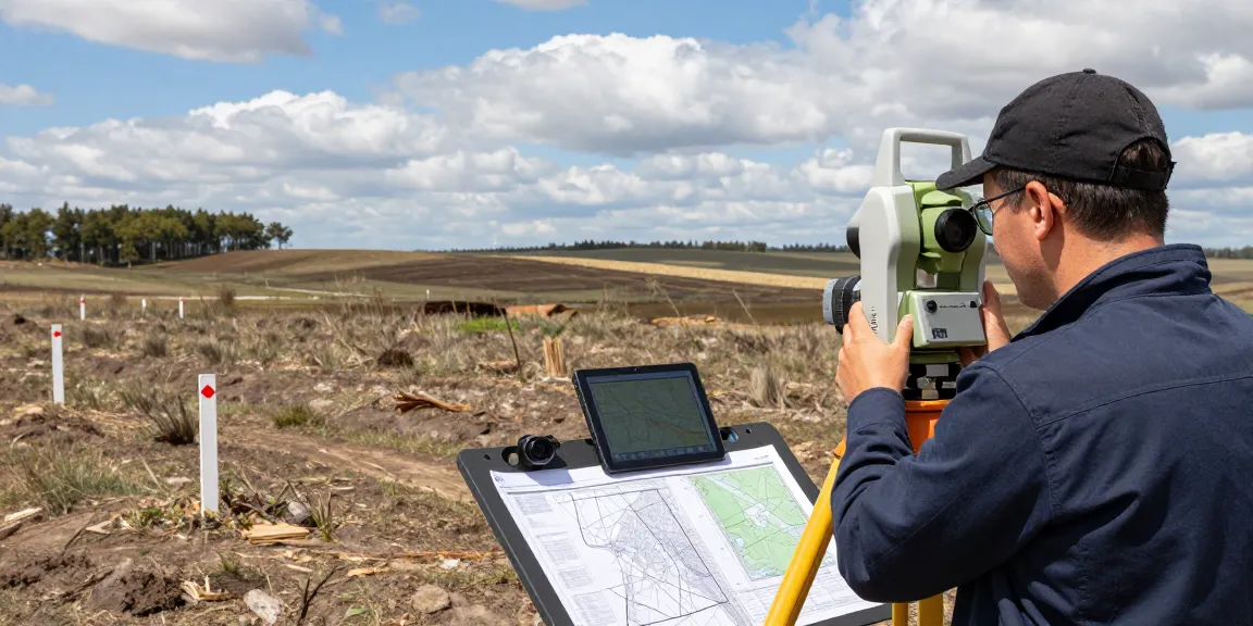
Essential Equipment for Topographical Surveys
Tools and Technology Used in the UK
Modern topographical surveys utilise state-of-the-art technologies for precision and efficiency. Key equipment employed by surveyors includes:
- Total Station Instruments: Utilises electronic distance measurement (EDM) and theodolite technology for accurate angle and distance measurements.
- GPS Surveying Equipment (GNSS): Provides quick and precise location data, especially useful on large, open sites.
- 3D Laser Scanners (LiDAR): Captures vast amounts of data for detailed 3D models of complex terrains.
- UAVs (Drone Surveys): Employs aerial mapping technology for inaccessible areas.
- Digital Level Instruments: Utilised for accurate measurements of vertical height differences.
Innovations in Surveying Equipment for 2026
As we move into 2026, innovations in surveying equipment continue to evolve, making surveys even more accessible and accurate. Advancements in AI technology, machine learning, and enhanced modular hardware will further streamline the survey process, enabling surveyors to analyse data more efficiently and produce rapid results.
Comparative Analysis: Traditional vs. Modern Techniques
Traditional surveying methods relied heavily on manual measurements and basic tools, which often limited accuracy due to human error and environmental factors. In contrast, modern techniques leverage sophisticated technology, providing higher accuracy rates, a richer data set, and reduced field time. This shift not only enhances the quality of surveys but also allows for more complex analyses and visualisations.
Preparing for Your Topographical Survey
What to Expect and How to Prepare
Engaging a surveyor for a topographical survey involves certain steps. Initially, clients should have a clear understanding of their project requirements, including the size of the area, specific features to be surveyed, and the intended use for the data. Clients should prepare by ensuring site access is available and providing any existing site plans or previous survey data for context.
Common Challenges and Solutions
Topographical surveys can face several challenges, such as:
- Access Issues: Difficult terrains or private properties may limit accessibility. Communicating with stakeholders and planning site visits in advance can mitigate these challenges.
- Environmental Conditions: Weather can affect survey accuracy. Surveyors often need to reschedule based on forecasted conditions to ensure optimal results.
- Data Overload: The vast amounts of data collected can be overwhelming. Employing advanced data software and analysis techniques can streamline data handling.
Choosing the Right Surveyor for Your Needs
When selecting a surveyor, consider their credentials, experience, and reputation within the industry. Checking their previous work, client reviews, and obtaining multiple quotes will help in making an informed decision. Furthermore, ensure they use the latest technology to guarantee accurate results.
Interpreting Topographical Survey Reports
Components of a Topographical Survey Report
A comprehensive topographical survey report typically includes:
- Site Plan: A detailed map illustrating all surveyed features.
- Elevation Profiles: Data on the land’s height and slope changes.
- Boundaries and Contours: Clear delineation of property lines and contours for better understanding.
- Notes on Relevant Features: Insights on vegetation, existing structures, and any obstructions.
How to Read and Utilise Survey Data
Understanding the nuances of a survey report can empower clients to make informed decisions. Familiarise yourself with the symbols, scales, and terminologies used in the report. This knowledge allows for better application of the data in project planning and execution.
Real-World Examples of Effective Survey Applications
There are numerous instances where effective utilisation of survey data has led to project success. For example, a large commercial development in London utilised detailed topographical data to navigate complex urban environments, ensuring compliance with local regulations while optimising design layouts. Similarly, infrastructure projects often rely on accurate land data to avoid ecological disturbances, demonstrating the importance of surveys in sustainable planning.
The Future of Topographical Surveys in 2026
Emerging Trends in Surveying Technology
The surveying industry is set to experience transformative changes with advancements in technology. Emerging trends include the integration of AI-driven analytics, automating repetitive data processing tasks, and improving the accuracy of survey outputs through enhanced predictive algorithms. Additionally, remote sensing technology is expanding the capabilities of surveyors, allowing for mapping in previously inaccessible locations.
Predictions for the Industry and Practice Changes
By 2026, the industry is likely to see a greater emphasis on real-time data collection and analysis, enabling faster decision-making and improved project timelines. Sustainability will also become a key focus, with an increasing number of surveys incorporating environmental assessments as standard practice.
How to Stay Ahead: Adapting to Changes in Surveying
To remain competitive, surveyors must adapt to technological advances and evolving regulations. Continuous professional development, staying informed about industry trends, and investing in the latest surveying tools are essential for success. Collaborating with other professionals in related fields can also lead to more integrated project approaches, enhancing overall outcomes.
What Are the Costs of Topographical Surveys?
Cost can vary significantly depending on several factors, including the scale of the project, complexity of the terrain, and the equipment used. Typical pricing ranges may fall between £450 to £1,500+, with smaller plots costing less and larger, more complex sites costing more. Choosing a reputable surveyor can help ensure you receive a fair quote with no hidden fees.
Frequently Asked Questions About Topographical Surveys
Many clients have common queries regarding topographical surveys, such as:
- Who Needs a Topographical Survey? Almost anyone involved in construction, landscaping, or land development will require a topographical survey.
- What Equipment is Commonly Used? Surveyors typically use total stations, GPS equipment, drones, and LiDAR technology.